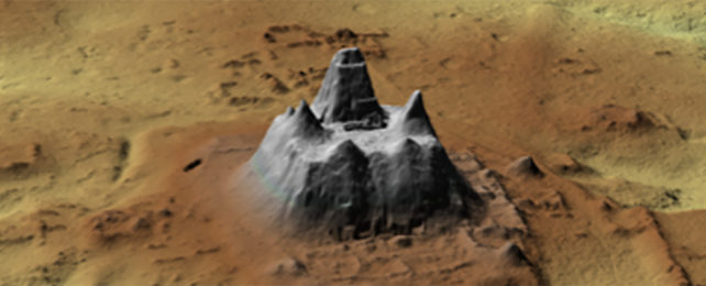
When it comes to discovering lost civilizations, it's a pretty big find: close to 1,000 previously hidden Maya settlements have been found in northern Guatemala thanks to LIDAR (Light Detection and Ranging) laser scanning from the air.
The area that these settlements cover is vast: the buildings and structures spotted by researchers stretch across some 650 square miles (1,683 square kilometers) of the Mirador-Calakmul Karst Basin (MCKB) and its immediate surroundings. These places would have been occupied around 1,000 BCE to 250 BCE.
Researchers from institutions in the US, Guatemala, and France note that the settlements that they've come across seem to have been quite densely packed, offering further evidence of how these early Mesoamerican places were populated.
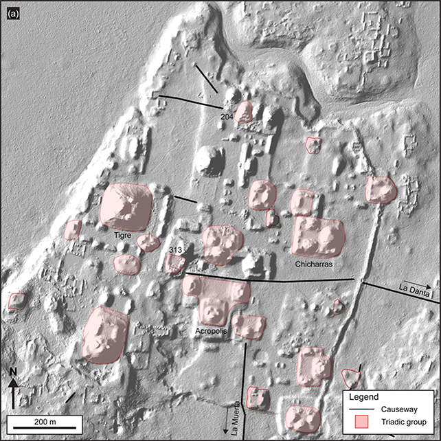
There's a lot in the new findings: buildings including homes, sports courts, and religious, ceremonial, and civic centers, as well as extensive networks of causeways and canals linking many of them together.
"Many of these settlements demonstrate a political/social/geographical relationship with other nearby settlements, which has resulted in the consolidation into at least 417 ancient cities, towns, and villages with identifiable site boundaries," write the researchers in their published paper.
The connections observed between the points of habitation suggest that this was all part of a kingdom-like state, in the sense that common ideologies and politics would probably have been shared across a lot of the newly revealed sites.
According to the researchers, numerous skills would've been required to build these structures: lime producers, mortar and quarry specialists, lithic technicians, architects, and legal enforcement and religious officials would all have been involved.
"The magnitude of the labor in the construction of massive platforms, palaces, dams, causeways, and pyramids dating to the Middle and Late Preclassic periods throughout the MCKB suggests a power to organize thousands of workers and specialists," write the researchers.
There's also evidence of smart drainage and water collection systems here, enabling an easier movement of water between settlements in times of drought or flood – something that the Maya people are known to have been experts at.
The light-based aerial scanning system offered by LIDAR means that scientists can easily peer below forest canopies and other vegetation growth to the solid structures beneath. In recent years we've seen it used to reveal Cambodian cities and Amazonian villages.
Now the technology has uncovered another vast civilization network that researchers are going to be able to dig into. We can expect more discoveries from this part of the world in the future, as well as more hidden places uncovered by LIDAR.
"Collectively, we argue that the development of infrastructure demonstrates the presence of complex societies with strong levels of socio-economic organization and political power during the Middle and Late Preclassic periods," write the researchers.
The research has been published in Ancient Mesoamerica.